© 2024 KPCW

KPCW
Spencer F. Eccles Broadcast Center
PO Box 1372 | 460 Swede Alley
Park City | UT | 84060
Office: (435) 649-9004 | Studio: (435) 655-8255

Music & Artist Inquiries: music@kpcw.org
News Tips & Press Releases: news@kpcw.org
Volunteer Opportunities
General Inquiries: info@kpcw.org
Listen Like a Local Park City & Heber City Summit & Wasatch counties, Utah
Play Live Radio
Next Up:
0:00
0:00
0:00 0:00
Available On Air Stations

Utah snowpack breaks 40-year-old record

Snow piles up at the crossing signal at the intersection of Deer Valley Drive and Park Avenue.
Parker Malatesta
Snow piles up at the crossing signal at the intersection of Deer Valley Drive and Park Avenue.

The storms will provide much-needed relief statewide, but our drought isn’t over.

Records keep piling up across Utah this winter.

Snowpack reached a new high after Thursday night’s storms. The snow water equivalent in Utah, or the amount of water the snow will release when its melts, sits at 26 inches as of Friday morning. That ties with the previous known record of 26 inches set on April 13, 1983, according to Utah Snow Survey data. And with the snow still falling, Friday is likely a new snowpack record.

Expect the record to keep rising — we still have 10 more days until snowpack reaches its typical peak, and there are plenty more storms in the forecast.
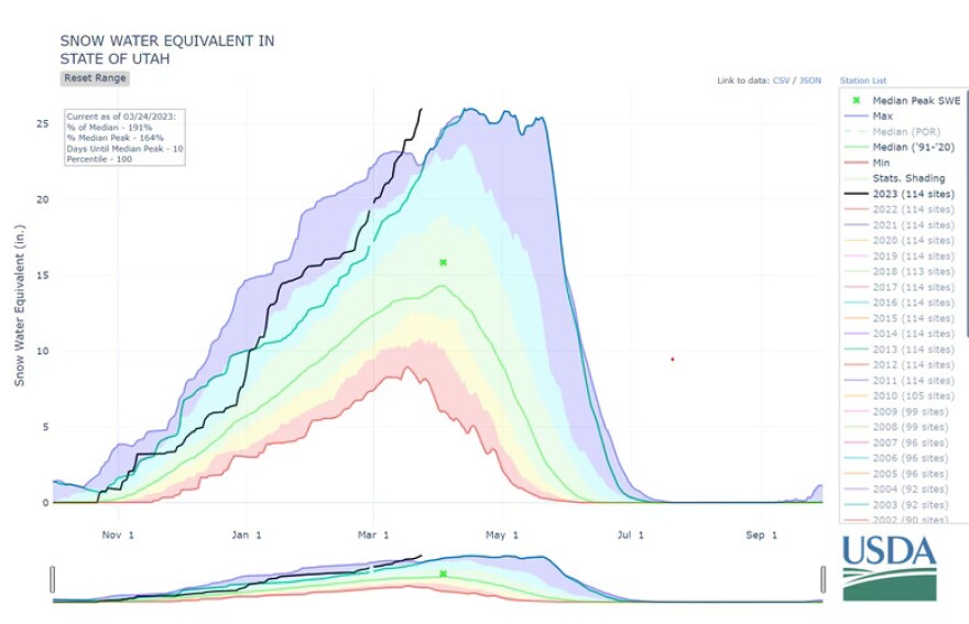
Screenshot from U.S. Natural Resources Conservation Service Utah Snow Survey. The black line marks the current snow year.

“It is amazing, and it’s kind of cool to be here to witness it,” said Jordan Clayton, supervisor of the Utah Snow Survey.

Read more at sltrib.com